"The Lake depth is invariably miss-reported by the media"
 |
Water Depth and Tide
"The Lake depth is invariably miss-reported by the media" |
A Note on Depth
Most documents refer to the depth of the Lake with a figure of "metres below sea level". While this is obviously quite correct, as mariners, the LEYC members like to sail on the sea rather than below it and so refer to depth as such - the amount of water above the lowest point in each of the basins described below. Further, for nautical purposes, the term "Tide" or more accurately a "Flood Depth" is also used. "Low Tide" being the lowest navigable level of water in a basin. This is normally governed by two physical limits - below low tide the Lake has water only over its mud/salt crusted bottom making beach access difficult and secondly, at this depth the water is super-saturated salt, making boating impossible.
From experience Low Tide has been generally defined as 1.5 metres above the lowest point in any particular basin.
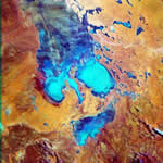
In order to understand the effect of flooding on Lake Eyre it is necessary to divide the Lake into three separate but interacting basins.
Note: For most purposes the northern half of Lake Eyre North can be considered as simply an alluvial fan. Water flowing over it to the southern end being only a few centimetres deep except in major floods such as in 74-77.
The Belt Bay & Jackboot Bay Basin
This basin is supplied with water almost annually by the Georgina/Diamantina/Warburton Rivers. Water is also supplied on a much less regular basis and in generally much lower volumes from the western rivers - The Finke, Macumba & Neales.
It is this basin that provides the best chance of boating in Lake Eyre North. The most recent occasions being Feb-Sept 1997 and March - ? 2000
The Madigan Gulf Basin
A Cooper flood acts in the reverse to a Warburton one but occurs less frequently, approximately every 10 years - the last being in 1990. It will fill Madigan Gulf to around 2 metres before overflowing into Belt Bay. The Clayton and Frome Rivers, although regularly flooding the area to the south-east of the Lake contribute only a small amount of water to Madigan Gulf which evaporation quickly removes.
The Lake Eyre South Basin
The most easily visited basin contains water most often. The Margaret, Stuart and Wariner Rivers are often flooded by summer thunderstorms and flow directly into the deepest end of the Lake. In 1984 such local weather filled the Lake to overflowing. LES has been navigable approximately every three years in recent times with maximum depths of 2 metres. Water is visible in the Lake biannually.
Interaction Between Basins
The Warburton flood will often fill the Belt-Jackboot Bay basin beyond capacity - approx 1.8 metres. When this occurs the basin overflows into the Madigan Gulf basin. This overflow is further encouraged by the prevailing SSW winds, which given time will push a significant portion of the Belt Bay water into the basin. See notes on Wind Tide elsewhere.
Water flowing into Madigan Gulf is spread over such a large area it evaporates rapidly. The evaporated water often causes severe thunderstorms to the SW and NW of the Lake, thus greening the neighbouring desert. As the flow rate is low and the evaporation rate is high Madigan Gulf rarely fills above 300mm. The wind tide/evaporation scenario can remove around 200mm per month from Belt Bay.
In extreme conditions when all Rivers flood into LEN such as in 1974 it will overflow into LES via the Goyder Channel and fill it. In 1984 a rare occurrence saw Lake Eyre South not only fill but overflow through the Goyder Channel to fill Madigan Gulf and Belt Bay to ~3 metres! Prior to this it was thought that floods could only travel from LEN to LES via the Channel.