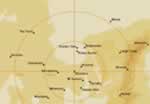
^ Georgina: Trickle
^ Eyre Ck: Flood ending Goyder Lagoon: Overflowing Kallakoopah: Pools Warburton: Minor Flood Macumba: Damp Lwr Warburton Lakes: Full Warburton Groove: Flowing
Upper claypan: Drying Neales: Damp Cooper: Minor flood Madigan Gulf: 2.3m Belt Bay: 2.3m navigable Clayton: Dry Lake Eyre South: 1.8m navigable Frome: Drying Lake Harry: 1.5m navigable Southern Creeks: Trickle
Page updated: 27 June 2026
WORLDVIEW: 26 June 2026
Courtesy of NASA
Overlay Copyright © 2026 Lake Eyre Yacht Club
LATEST NEWS (click Refresh):
Warburton flood ending
Second Cooper pulse trickles through Innamincka. Won't reach Birdsville Track.
LAKE EXCEEDING LAST YEARS LEVEL
HOWEVER LEVEL STABILISING
Contrary to media reports Lake will nowhere near fill.
Lake Eyre South will not overflow into Lake Eyre North